GEOS-5 AGCM Overview: Difference between revisions
Jump to navigation
Jump to search
No edit summary |
No edit summary |
||
| Line 9: | Line 9: | ||
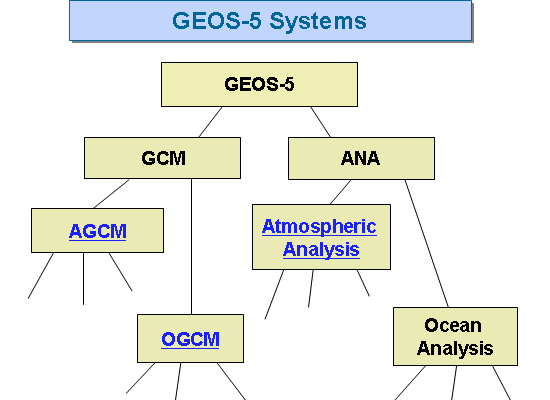
Image:GEOS5_structure.gif| | Image:GEOS5_structure.gif| | ||
rect 67 219 130 243 [[]] | rect 67 219 130 243 [[AGCM Structure]] | ||
desc none | desc none | ||
</imagemap> | </imagemap> | ||
Revision as of 07:05, 11 June 2008
The Goddard Earth Observing System Model, Version 5 (GEOS-5) is a system of models integrated using the Earth System Modeling Framework (ESMF). The GEOS-5 DAS integrates the GEOS-5 AGCM with the Gridpoint Statistical Interpolation (GSI) atmospheric analysis developed jointly with NOAA/NCEP/EMC. The GEOS-5 systems are being developed in the GMAO to support NASA's earth science research in data analysis, observing system modeling and design, climate and weather prediction, and basic research.